Huasco Valley
Huasco River basin results from the joining of the Tránsito and El Carmen rivers (in San Félix Valley, former Valley of the Spaniards), 90 km east from the coastline. Heavy morning mists coming from the seafront is one notable feature of the valley.
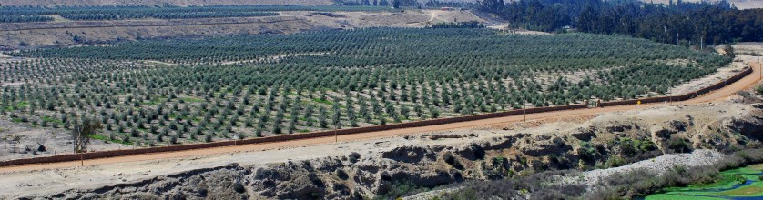
The Huasco River basin is located south of the region between 28°33’ and 29°22’ latitude South and is a product of the joining of two rivers: Tránsito (in the Tránsito Valley) and El Carmen (in the San Félix Valley) at 670 m.a.s.l. and 90 km from its mouth. It has a mixed flow pattern of rains and spring thaws. Both rivers have several networks of irrigation canals, which limit the flow toward the lower reaches. Similarly, the groundwater table’s level diminishes, due to the large number of wells that use them.
History tells that in the XVII century, in the area where the city of Vallenar stands and before the foundation of this capital of the Huasco Province, a group of Spaniards uses to produce there a particular kind of wine. The city of Vallenar was founded as San Ambrosio de Ballenary by Ambrose O’Higgins in 1789, after his birthplace in Ballynary in County Sligo, Ireland. In fact, the priests from the Order of Mercedarios under the protection of the landlord (encomendero under the Spanish Crown rule) Jerónimo Ramos de Torre, established from 1732 in El Rosario, El Carmen Valley, which was called for a long time the Valley of the Spaniards. The Mercedario priests start the production of wine and eau-de-vie (aguardiente, a spirit made from wine distillation). The wine was produced to be consumed during the celebration of the Catholic mass, and become known as “mercedario” in direct reference to their producers. A time later the Jesuits priests brought the production techniques from Spain to El Carmen Valley. This drink was brought as a sacramental wine from Andalucía’s vineyards, located in Monte de Pajarete, in the Jerez area in the south of Spain; therefore, the wine abandoned its denomination mercedario to become pajarete. Its legacy was passed down generations to several corners of Huasco Alto’s inner valleys, which are why it was possible to find different types of this particular kind of wine called pajarete and so many different elaboration procedures. Apparently, pajarete is more related to the history of Huasco since 90% of its production has historically been made in the Huasco Valley.
The Pajarete wine, also Paxarette, is the name of a Spanish sweet condensed wine made generally with Pedro Ximénez grapes and finished by mixing the wine with essences, called arrope or sancocho, which are produced by boiling must down to a fifth and a third respectively. Pajarete was popular as a straight dessert wine in England in the 18th century and gets its name from a monastery and vineyards situated near Arcos de la Frontera in the province of Cadiz in Andalusia southern Spain. In the past, the Scotch whisky industry made use of Paxarette to season casks, simply by pouring this rich flavouring into the wood, to help impart a fuller, richer sherry character into the whisky that was aged in them. Casks are conditioned by using pressure to force the paxarette to enter the upper layers of tired or spent sherry casks. As J.M. Philp describes in 1989, “…a typical current cooperage procedure in the Scotch whisky industry is to add 500 ml of Paxarette per hogshead, or 1 litre per butt, pressurise at 48 kPa (7psig) for 10 min and then disgorge any unabsorbed Paxarette.”
In 1873, Nicolás Naranjo Palacios, a wealthy businessman built the Armidita canal, which is 14 km long and allowed the creation of the estate Armidita and to irrigate another property called Juntas. A Spanish vintner was hired to plant 250 hectares of vines. After some years, in 1882 an Italian vintner Giovanni Rollando also comes to be part of the effort and Julio Figueroa was hired as manager of the venture. The wine from this Valley of the Spaniards, the pajarete from Armadita, was awarded at the Exposition Universelle of 1889 held in Paris, France, celebrating the 100th anniversary of the storming of the Bastille, during the French Revolution. Some decades have passed until 1972, when Don Gudelio Ramirez Muñoz alongside with his wife, Violeta Ibarbe decided to make the renaissance of the Armidita estate as a fine wine producer estate.
The rediscovery and development of pajarete in recent times starts in a very rustic way and in small quantities, looking to recovery the finesse of the ancient colonial winemaking process. Grapes are partially dehydrated through sundry techniques. This technique consists in exposing the bunches of grapes to the sun in a dehydration area (asoleo), where the sundry time period depends on each producer’s experience, grape harvest conditions and the time available to continue with the process.
Denomination of Origin: Huasco Valley
Region: Atacama
Sub-Region: Huasco
One wine company has presence of importance in the Huasco Valley
Armidita Winery, http://armidita.cl/en
Soils
The relief of the Atacama Region is uneven: transversal valleys and interfluvial highlands predominate, alternating over the whole region. The Andean Range reaches heights more than 6,000 m.a.s.l. with outstanding peaks such as the Nevado San Francisco, Incahuasi, Tres Cruces and the Nevado Ojos del Salado which is 6,893 metres high and it’s the highest mountain in Chile. To the north of the region the slopes of the Andes turn into a piedmont high plateau, with saline basins along its length, forming a group of small Andean salt lakes. The precordilleran sector’s average height is of between 3,000 and 4,500 metres, broken by outcrops from the continuation of the Domeyko mountain range towards the South, which results in a group of transversal high-lands. The inland relief north of the Copiapó River becomes narrow, with pampas or basins developing between the highlands at the Andean foothills and coastal reliefs. In the central sector of the region’s territory a transversal valley appears, framed to the north by a highlands range, this transversal valley corresponds to the Copiapó River which is born in the foothills of the Andes, and flows from the Southeast to the Northwest.
To the South of the region a second transversal valley appears, which is the Huasco River basin. The relief of this zone is in general a succession of smaller mountain ranges and transversal East-West valleys. By contrast the Coastal Range turns into a series of outcrops, due to the transversal ranges and rivers, as well as, to a lesser extent to marine erosion. This results in wide coastal plains in the zone of Chañaral. The sunken basin is interrupted by transversal hills that frame deeper river valleys the most noteworthy of which are the valleys of the Copiapó and Huasco rivers. In this zone the soils are those found in arid and semiarid highlands. In the northern sector of the Atacama Region soils present a one-metre deep calcareous duricrust horizon. Further south the lands of the sunken basin plains are those of a desert, and have developed due to the increase of the precipitation and resulting plant cover. Continuing towards the South of the region there are soils derived from sediments of a medium to fine texture. They are thin and moderately deep with a clay horizon in depth. Soils with little development predominate in the precordillera and mountain range; these generally are bare soils as normally found in steep slopes of craggy hills. Scarcely developed soils appear in the inland areas of the region, due to aridity. In the Central Valley of the region this type of soil derives from thick sediments with a large salt content and a high pH. On the coast the soils are thin, stratified, and of a stony profile, due to their colluvial origin.
Climate
The Atacama Region is characterised by a semiarid climate and the presence of deserts. In the northern boundary of the region the climate is very arid; however, as one goes South of Copiapó the level of winter rains increases gradually. To the South of the city of Copiapó the climate be-comes that of the fringe of a desert and then gradually turns into a hot steppe climate. Four types of climate are found in this region. The coastal strip of the region has a desert seafront climate that continues inland in the Copiapó and Huasco valleys, presenting heavy morning mists. The scarce rains reach only 8 mm a year and the mean annual temperature is of 16,1°C with a relative humidity of 74%. In the sunken basin and especially in the reliefs of the Pampas, which have the Copiapó River as their southern boundary, there is an inland desert climate whose main characteristics are high temperatures during the day, the absence of clouds and rainfall. South of the Copiapó valley and towards the southern boundary of the region, the climate is of the desert fringe type. This climate is characterised by greater annual rainfalls, increasing towards the South. The average annual temperature is 15°C and humidity tends to disappear as we proceed inland through the valleys and transversal hill ranges. Desert conditions lessen and precipitation increases, the zone is then characterised as a semi-desert. In the Andean zone and above 2,000 metres there is a fringe of high desert climate. Rainfall is more abundant, above 250 mm a year, and solid precipitation predominates upon the higher peaks. The presence of snows in this area allows rivers fed by rains and melting snows to flow during the whole year. Temperatures are lower and the fluctuation between day and night increases.