Itata Valley
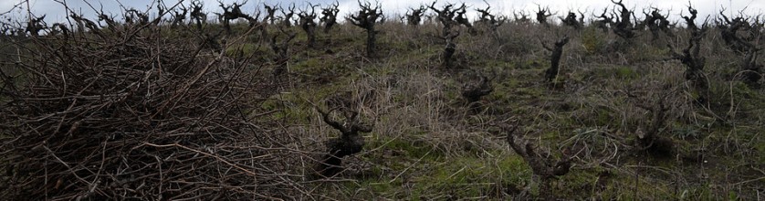
Once the viticultural centre of the new world’s Spanish Crown colony, where vines were planted as far back as the first decade of the 1600s, the Itata steep granitic hills are a forgotten viticultural region which survived in spite of being for a long time neglected. Some varieties, such as País, adapted so well to the terroir, that it is no rare to find old head-trained vines which have reached over 100 years old.
The Itata Valley is comprised within the Bío-Bío administrative region which is the southern boundary of the viticultural zone of the Central Valley, between 36º 00′ and 38º 30’ latitude south. Its boundaries are, to the north the Maule administrative region and south the Araucanía administrative region. The Valley was named after the homonymous river which is formed by the Ñuble and the Itata watercourses.
The Itata Valley is a small sheltered treasure for winegrowing of the Biobío Region, whose winegrowing tradition dates back to the XVI century and where the very old head-trained vines are found scattered and perfectly adapted on the steep granitic hills. The Itata Valley hides within its vineyards the history of Chilean viticulture.
It is not easy to find a winegrowing landscape as unique as this one. The Itata Valley spreads out for 100 kilometers, between the cities of San Carlos on the north and Bulnes on the south, in the Ñuble province. The non irrigated vines of rustic varieties, such as Muscat, País and Cinsault, have perfectly adapted to the soil and climate of the valley, making up great extensions of vines that do not involve wires or any other system of support. Encountering those large green fields rolling over until the sight is lost; covering slopes and small hills all the way into the horizon is a unique landscape.
Denomination of Origin: Itata
Region: Southern Region
Sub-Region: Itata
Complementary Areas: Costa, Entre-Cordilleras, Andes
Soils
On the coast there are soils developed from marine terraces, flat or with soft slopes of reddish brown colour associated to other less developed soil types. Inland, in the highlands between Los Ángeles and Loncoche, the coastal sector, facing Moche Island, and in the heights of the Coastal Range the soils are thin and show drainage problems. In the eastern sector they are moderately deep and have high clay content.
In the inland valleys soils are alluvial and moderately developed between the cities of Los Ángeles and Malleco, next to soils formed from coarse-grained basaltic sands. These soils are highly permeable and there also are sectors with high groundwater levels. In the precordillera and the sectors of stronger relief of the Andes there are coarse-grained soils derived from volcanic accumulation. In the precordillera facing the city of Los Ángeles and down to Temuco, there are soils derived from volcanic ashes, known as “trumaos”. These are rich soils, deep, with high organic matter content and a great moisture retention capacity.
Climate
The Southern vine-growing Region is characterised, by a cold temperate climate with important differences between the coast and its inland valleys. The orographic conditions of the region do not allow winds from the ocean to enter the sunken basin; this causes a wide thermal variation between them. The rains increase as the territory continues towards the south increasing the diversity and amount of vegetation and the presence of rivers of greater volume. In the southern viticultural region the average rainfall and high humidity at some times of the year provide better soils for agriculture and stock farming. The difference between the coast and the sunken basin is still very noticeable as to humidity, thermal variation as well as increased rainfall. The southern viticultural region has two dominant river basins which form the hydrographic system of the region: the Itata and Bio Bío rivers, both born in the Andes and originating homonymous valleys. There are also lesser river basins, such as that of the Andalién River.
Two main watercourses form the Itata River: the Ñuble and Itata rivers. The Itata River is 180 km long, including its two affluents, the Cholguán and Huépil. The Itata River has a mixed flow pattern, since its main affluents are born in the mountain range and precordillera of the Andes and are fed spring thaws and winter rainfall. This River crosses the longitudinal valley and has a high waterfall due to an abrupt change of level of the land. In its lower reaches its main affluent is the Lonquén River, which drains the cordilleran sector of the coast to the north.
The Bío Bío River has one of the largest basins of the country and a mixed flow pattern with spates in winter and spring; it is 380 kilometres long. It is born from the Andes in the region of the Araucanía, draining two mountain lakes, the Icalma and the Galletué. In its middle course it receives the contribution of the Duqueco and the Bureo. Going through the longitudinal valley, the Bío Bío River changes course as it comes against the Coastal Range, and then it returns to its normal course in the confluence with the Vergara River. Near the coast the river receives the waters of the Laja River, its largest affluent. In its lower reaches, near the city of Concepción, the river again changes its course reaching the sea south of the Hualpén hills.