Copiapó Valley
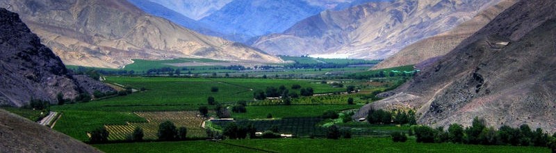
Copiapó Valley took its name from the homonymous river born from the confluence of the tributaries Jorquera, Pulido and Manflas, at 1,400 m.a.s.l. and 90 kilometers East from the city of Copiapó, in Juntas. The Copiapó River is intensively used for agricultural purposes, the irrigation of fluvial terraces and fertile plains sectors, which also receive abundant mists.
The Copiapó Valley lies between 26° 30’ and 28° 36’ latitude South. It is the northern viticultural valley belonging to the northern viticultural region. The Copiapó River is 162 kilometres long and is born from the confluence of the tributaries Jorquera, Pulido and Manflas, which meet at 1,400 m.a.s.l. and about 90 kilometres inland from the city of Copiapó, in the locality of Juntas. The total length of the Valley is 145 km and its average width is 1.5 km. The Copiapó River is intensively used for agricultural purposes, the irrigation of fluvial terraces and fertile plains sectors, which also receive abundant mists.
Denomination of Origin: Copiapó Valley
Region: Atacama
Sub-Region: Copiapó
Soils
The relief of the Atacama Region is very uneven: transversal valleys and interfluvial highlands pre-dominate, alternating over the whole region. The Andean Range reaches heights more than 6,000 m.a.s.l. with outstanding peaks such as the Nevado San Francisco, Incahuasi, Tres Cruces and the Nevado Ojos del Salado which is 6,893 metres high and iis the highest mountain in Chile.
To the north of the region the slopes of the Andes turn into a piedmont high plateau, with saline basins along its length, forming a group of small Andean salt lakes. The precordilleran sector’s average height is of between 3,000 and 4,500 metres, broken by outcrops from the continuation of the Domeyko mountain range towards the South, which results in a group of transversal high-lands. The inland relief north of the Copiapó River becomes narrow, with pampas or basins developing between the highlands at the Andean foothills and coastal reliefs. In the central sector of the region’s territory a transversal valley appears, framed to the north by a highlands range, this transversal valley corresponds to the Copiapó River which is born in the foothills of the Andes, and flows from the Southeast to the Northwest.
To the South of the region a second transversal valley appears, which is the Huasco River basin. The relief of this zone is in general a succession of smaller mountain ranges and transversal East-West valleys. By contrast the Coastal Range turns into a series of outcrops, due to the transversal ranges and rivers, as well as, to a lesser extent to marine erosion. This results in wide coastal plains in the zone of Chañaral. The sunken basin is interrupted by transversal hills that frame deeper river valleys the most noteworthy of which are the valleys of the Copiapó and Huasco rivers. In this zone the soils are those found in arid and semiarid highlands. In the northern sector of the Atacama Region soils present a one-metre deep calcareous duricrust horizon. Further South the lands of the sunken basin plains are those of a desert, and have developed due to the increase of the precipitation and resulting plant cover.
Continuing towards the South of the region there are soils derived from sediments of a medium to fine texture. They are thin and moderately deep with a clay horizon in depth. Soils with little development predominate in the pre-cordillera and mountain range; these generally are bare soils as normally found in steep slopes of craggy hills. Scarcely developed soils appear in the inland areas of the region, due to aridity. In the Central Valley of the region this type of soil derives from thick sediments with a large salt content and a high pH. On the coast the soils are thin, stratified, and of a stony profile, due to their colluvial origin.
Climate
The Atacama Region is characterised by a semiarid climate and the presence of deserts. In the northern boundary of the region the climate is very arid; however, as one goes South of Copiapó the level of winter rains increases gradually. To the South of the city of Copiapó the climate becomes that of the fringe of a desert and then gradually turns into a hot steppe climate. Four types of climate are found in this region.
The coastal strip of the region has a desert seafront climate that continues inland in the Copiapó and Huasco valleys, presenting heavy morning mists. The scarce rains reach only 8 mm a year and the mean annual temperature is of 16,1 °C with a relative humidity of 74%. In the sunken basin and especially in the reliefs of the Pampas, which have the Copiapó River as their southern boundary, there is an inland desert climate whose main characteristics are high temperatures during the day, the absence of clouds and rainfall.
South of the Copiapó valley and towards the southern boundary of the region, the climate is of the desert fringe type. This climate is characterised by greater annual rainfalls, increasing towards the South. The average annual temperature is 15 °C and humidity tends to disappear as we proceed inland through the valleys and transversal hill ranges. Desert conditions lessen and precipitation increases, the zone is then characterised as a semi-desert.
In the Andean zone and above 2,000 metres there is a fringe of high desert climate. Rainfall is more abundant, above 250 mm a year, and solid precipitation predominates upon the higher peaks. The presence of snows in this area allows rivers fed by rains and melting snows to flow during the whole year. Temperatures are lower and the fluctuation between day and night in-creases.