Cauquenes Valley
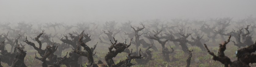
Cauquenes Valley is a sub-region of the Tutuvén Valley within the Maule Valley.The main variety here consists of very old goblet-trained Carignan vines. Questo è un vigneto secco allevamento senza irrigazione e rese molto basse, garantendo così una perfetta combinazione di frutta concentrato e complessità del vino. La maggior parte del terreno è argilloso-based e profondo, con bassa fertilità.
La Valle Cauquenes si trova nella Valle Tutuvén, all'interno della viticoltura Regione Maule, e sono caratterizzate dalla loro topografia ondulata e terreni eterogenei. Con un sub-umido clima mediterraneo, mostra stagioni ben marcate, elevate quantità di luce solare, e della piovosità annua di 700 millimetri. Queste condizioni consentono la valle di presentare un'ampia oscillazione termica che va da 15 ° a 18 ° Celsius, permettendo una adeguata crescita e maturazione delle uve, dando, in seguito, frutto che presenta una migliore espressione varietale. Oggi, Questa valle spettacoli promettono di dare Cile una varietà di vini la cui qualità e l'identità sono raramente prima stato visto.
Carignan old vines are common in the Cauquenes Valley and has been rediscovery as a neglected treasure of the Chilean wine industry. Vigneti Carignan sono stati piantati su larga scala nella regione di Maule Valley nei primi anni 1940, in cui, a seguito di un catastrofico terremoto in 1939, il Ministero dell'Agricoltura ha proposto incoraggiare la messa a dimora di Carignan a migliorare i vini della regione. Il pensiero era che la natura elevata acidità e il colore di Carignano migliorerebbe i vini locali. Quindi per più di,en,In questa zona le Ande sono caratterizzate dalla presenza di vulcani che definiscono i confini del paesaggio del bacino sommerso e non sono più alti del,en,ad eccezione del vulcano Peteroa,en,seguito dal Descabezado Grande,pt,ce ne sono anche altri come il Descabezado Chico e il Quizapu,en,L'attività vulcanica e l'azione glaciale hanno generato piccoli laghi della Cordigliera,en,come la Laguna del Maule,en,nel bacino orientale di quel fiume,en,Tra la precordillera e la Cordigliera Costiera troviamo la Valle Longitudinale,en,che è più ampio,en,a Linares e ha una lunghezza di,en,Il suo rilievo è pianeggiante e interrotto da numerosi fiumi che lo attraversano da est a ovest,en,verso il centro e il sud della regione un rilievo precordiglierano di,en,appare tra il bacino infossato e le Ande,en,Questo sollievo,en 50 anni i vigneti di Maule sono stati a casa ad asciugare cresciuto, vitigno vecchio Carignano. Precedentemente una varietà cavallo di lavoro che è stato utilizzato per mescolare, Enologi cileni si stanno rendendo conto che hanno una risorsa preziosa.
Denominazione di Origine: Maule
Regione: Central Valley
Sub-Regione: Maule
Comprende le zone: Cancella, Loncomilla, Tutuvén (Oche)
Settori complementari: Tra Cordigliera, Ande
Suoli
In this zone the Andes are characterised by the presence of volcanoes that define the boundaries of the sunken basin landscape and are no higher than the 4,000 m.a.s.l. except for the Peteroa volcano, 4.090 metri di altezza, followed by the Descabezado Grande 3,830 metri di altezza; there are also others such as the Descabezado Chico and Quizapu. Volcanic activity and glacial action have generated small cordilleran lakes, such as the Laguna del Maule 3,000 m.a.s.l. in the eastern basin of that river. Between the precordillera and the Coastal Range we find the Longitudinal Valley, which is widest (40 chilometri) at Linares and has a length of 170 chilometri. Its relief is flat and interrupted by many rivers that cross it from East to West.
Tuttavia, towards the centre and South of the region a precordilleran relief of 400 a 1,000 m.a.s.l. appears between the sunken basin and the Andes. This relief, che maschera il bacino infossato,en,è noto come,en,La catena costiera è bassa,en,con morbide colline che incorniciano bacini e valli,en,Questa gamma è divisa in due catene,en,uno di questi dà origine al bacino di Cauquenes,en,al sud della regione,en,che presenta particolari condizioni microclimatiche,en,Le altezze non superano i,en,Le pianure fronte mare sono ben sviluppate,en,con terrazze fino a,en,e largo circa cinque chilometri interrotto da corsi d'acqua che sfociano nel mare,en,Ci sono ampie spiagge,en,come Constitución e le dune nella zona di Putú,en,COSÌ,ny,e Curanipe,en,Nel versante occidentale della catena costiera,en,nonché nelle zone immediatamente a nord di esso,en,i terreni sono ben evoluti da rocce granitiche,en,con contenuto di argilla in profondità,en,Nel settore vicino alla costa i suoli derivano da alti terrazzamenti marini,en, is known as “La Montaña”. The Coastal Range is low (tra 300 e 700 m.a.s.l.) with soft hills framing basins and valleys. This range is divided into two chains, one of these originates the Cauquenes basin (to the South of the region), which has special microclimatic conditions. Heights do not exceed the 900 m.a.s.l. Seafront plains are well developed, with terraces of up to the 200 m.a.s.l. and about five kilometres wide interrupted by rivers that flow into the sea. There are wide beaches, such as Constitución and dunes in the zone of Putú, Chanco, and Curanipe. In the western slope of the Coastal Range, as well as in the zones immediately north of it, the soils are well evolved from granitic rocks, with clay content in depth. In the sector near the coast the soils derive from high marine terraces, sono di colore bruno-rossastro e il loro rilievo è piatto o con pendii morbidi,en,Suoli che possono invertirsi a causa della dilatazione e contrazione delle argille e la cui origine è il deposito di sedimenti fini in condizioni lacustri si trovano nei pressi della città di Parral,en,Nella Valle Centrale,en,La maggior parte dei terreni irrigati si trovano in questi terreni della regione viticola del Maule,en,Nella precordillera e nei settori di maggior rilievo delle Ande troviamo suoli a grana grossa derivati da accumuli vulcanici,en,Caratteristica è la regione della valle del Maule,en,da un clima temperato con ampie differenze tra la costa e le valli interne,en,diverso da quanto avviene sulla costa,en,dove le nebbie marine sono presenti praticamente tutto l'anno,en,e mostra nell'umidità,en,variazioni termiche e precipitazioni,en. Soils that can reverse due to dilatation and contraction of the clays and whose origin is the deposit of fine sediments in lacustrine conditions are found near the city of Parral.
In the Central Valley, tra la Catena Costiera e le Ande, troviamo terreni alluvionali di moderato sviluppo. Most of the irrigated lands are sited in these soils of the Maule viticultural region. In the precordillera and the sectors of stronger relief of the Andes we find coarse-grained soils derived from volcanic accumulation.
Clima
The region of the Maule valley is characterised, come altre regioni della valle centrale del Cile, by a temperate climate with wide differences between the coast and its inland valleys. Le condizioni orografiche della regione non consentono venti dall'oceano di entrare nel bacino affondata; this causes a wide thermal range, different to what occurs on the coast, where sea fogs are present practically during the whole year. The difference between the coast and the sunken basin is significant, and shows in humidity, thermal variation and rainfall. Il bacino di Cauquenes,en,A sud della regione,en,presenta particolari condizioni microclimatiche,en,Le piogge sono più abbondanti man mano che il territorio prosegue verso sud, aumentando la diversità e la densità della vegetazione e alimentando fiumi di maggiore portata,en,La regione viticola del Maule è influenzata dal sistema idrografico del fiume Maule,en,che nasce nelle Ande e ha come affluente nel suo corso superiore il Puelche,en,I Cipressi,es,Fiumi Claro e Melado,pt,Ha anche il fiume Loncomilla come affluente nel bacino sommerso,en,ed entra nel mare vicino alla città di Constitución,en, South of the region, shows special microclimatic conditions. The rains are more abundant as the territory continues towards the South increasing the diversity and density of the vegetation and feeding rivers of greater volume. The Maule viticultural region is influenced by the hydrographic system of the river Maule, which is born in the Andes and has as tributaries in its higher course the Puelche, Los Cipreses, Claro and Melado rivers. It has also the Loncomilla River as affluent in the sunken basin, and enters the sea near the city of Constitución.