Cauquenes Valley
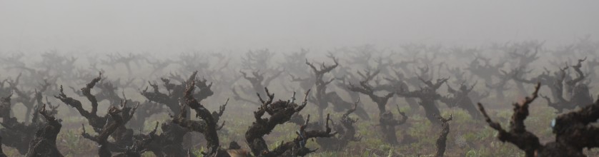
Cauquenes Valley is a sub-region of the Tutuvén Valley within the Maule Valley.The main variety here consists of very old goblet-trained Carignan vines. Il s'agit d'un vignoble à sec élevage sans irrigation et avec des rendements très faibles, assurant ainsi une combinaison parfaite de fruits concentré et de la complexité dans le vin. La plupart des sols est à base d'argile et profond, à une faible fécondité.
La vallée de Cauquenes est situé dans la vallée Tutuvén, dans la région viticole de Maule, et sont caractérisées par leur topographie ondulée et sols hétérogènes. Avec un climat méditerranéen sub-humide, il montre saisons bien marquées, de grandes quantités de la lumière du soleil, et des précipitations annuelles de 700 mm. Ces conditions permettent la vallée de présenter une grande fluctuation thermique qui va de 15 ° à 18 ° Celsius,, permettant une croissance adéquate et la maturation des raisins, donnant, à la suite, fruit qui présente une meilleure expression variétale. Aujourd'hui, Cette vallée est prometteuse pour donner Chili une variété de vins dont la qualité et l'identité ont rarement été vu auparavant.
Carignan old vines are common in the Cauquenes Valley and has been rediscovery as a neglected treasure of the Chilean wine industry. Vignes de Carignan ont été plantés sur une grande échelle dans la région de Maule Valley dans les années 1940, lors de, à la suite d'un tremblement de terre catastrophique en 1939, Ministère de l'Agriculture a proposé d'encourager la plantation de Carignan pour améliorer les vins de la région. L'idée était que la forte acidité naturelle et la couleur de Carignan amélioreraient les vins locaux. Donc depuis plus de,en 50 ans les vignobles de Maule ont été à la maison pour sécher adulte, vieille vigne Carignan. Auparavant une variété de bourreau de travail qui a été utilisé pour mélanger, Vignerons chiliens se rendent compte maintenant qu'ils ont une ressource précieuse.
Dénomination d'Origine: Maule
Région: Vallée Centrale
Sous-Région: Maule
Comprend des zones: Effacer, Loncomilla, Tutuvén (Oies)
Domaines complémentaires: Entre Cordillères, Andes
Sols
In this zone the Andes are characterised by the presence of volcanoes that define the boundaries of the sunken basin landscape and are no higher than the 4,000 m.a.s.l. except for the Peteroa volcano, 4.090 mètres de haut, followed by the Descabezado Grande 3,830 mètres de haut; there are also others such as the Descabezado Chico and Quizapu. Volcanic activity and glacial action have generated small cordilleran lakes, such as the Laguna del Maule 3,000 m.a.s.l. in the eastern basin of that river. Between the precordillera and the Coastal Range we find the Longitudinal Valley, which is widest (40 kilomètres) at Linares and has a length of 170 kilomètres. Its relief is flat and interrupted by many rivers that cross it from East to West.
Cependant, vers le centre et le sud de la région un relief précordillaire de,en,apparaît entre le bassin englouti et les Andes,en,Ce soulagement,en,qui masque le bassin englouti,en,est connu sous le nom,en,La chaîne côtière est faible,en,avec des collines douces encadrant des bassins et des vallées,en,Cette gamme est divisée en deux chaînes,en,l'un d'eux est originaire du bassin des Cauquenes,en,au sud de la région,en,qui a des conditions microclimatiques particulières,en,Les hauteurs ne dépassent pas,en,Les plaines du front de mer sont bien développées,en,avec des terrasses allant jusqu'au,en,et environ cinq kilomètres de large interrompu par des rivières qui se jettent dans la mer,en,Il y a de larges plages,en,comme la Constitución et les dunes de la zone de Putú,en,Donc,ny,et Curanipe,en,Sur le versant ouest de la chaîne côtière,en,ainsi que dans les zones immédiatement au nord de celui-ci,en,les sols sont bien évolués à partir de roches granitiques,en 400 à 1,000 m.a.s.l. appears between the sunken basin and the Andes. This relief, which masks the sunken basin, is known as “La Montaña”. The Coastal Range is low (entre 300 et 700 m.a.s.l.) with soft hills framing basins and valleys. This range is divided into two chains, one of these originates the Cauquenes basin (to the South of the region), which has special microclimatic conditions. Heights do not exceed the 900 m.a.s.l. Seafront plains are well developed, with terraces of up to the 200 m.a.s.l. and about five kilometres wide interrupted by rivers that flow into the sea. There are wide beaches, such as Constitución and dunes in the zone of Putú, Chanco, and Curanipe. In the western slope of the Coastal Range, as well as in the zones immediately north of it, the soils are well evolved from granitic rocks, avec une teneur en argile en profondeur,en,Dans le secteur proche de la côte, les sols proviennent de hautes terrasses marines.,en,sont de couleur brun rougeâtre et leur relief est plat ou avec des pentes douces,en,Près de la ville de Parral se trouvent des sols qui peuvent s'inverser en raison de la dilatation et de la contraction des argiles et dont l'origine est le dépôt de sédiments fins en conditions lacustres.,en,Dans la Vallée Centrale,en,La plupart des terres irriguées sont situées sur ces sols du terroir viticole du Maule.,en,Dans la précordillère et les secteurs de relief plus fort des Andes, nous trouvons des sols à grains grossiers issus de l'accumulation volcanique.,en,La région de la vallée du Maule se caractérise,en,par un climat tempéré avec de grandes différences entre la côte et ses vallées intérieures,en,différent de ce qui se passe sur la côte,en. In the sector near the coast the soils derive from high marine terraces, are reddish brown in colour and their relief is flat or with soft slopes. Soils that can reverse due to dilatation and contraction of the clays and whose origin is the deposit of fine sediments in lacustrine conditions are found near the city of Parral.
In the Central Valley, entre la chaîne côtière et les Andes, on trouve des sols alluviaux de développement modéré. Most of the irrigated lands are sited in these soils of the Maule viticultural region. In the precordillera and the sectors of stronger relief of the Andes we find coarse-grained soils derived from volcanic accumulation.
Climat
The region of the Maule valley is characterised, que d'autres régions de la vallée centrale du Chili, by a temperate climate with wide differences between the coast and its inland valleys. Les conditions orographiques de la région ne permettent pas les vents de l'océan pour entrer dans le bassin en contrebas; this causes a wide thermal range, different to what occurs on the coast, où les brouillards marins sont présents pratiquement toute l'année,en,et se voit dans l'humidité,en,variation thermique et précipitations,en,Le bassin de Cauquenes,en,Sud de la région,en,montre des conditions microclimatiques particulières,en,Les pluies sont plus abondantes à mesure que le territoire continue vers le sud, augmentant la diversité et la densité de la végétation et alimentant des rivières de plus grand volume.,en,La région viticole du Maule est influencée par le système hydrographique de la rivière Maule,en,qui naît dans les Andes et a pour affluents dans son cours supérieur la Puelche,en,Les Cyprès,es,Rivières Claro et Melado,pt,Il a également la rivière Loncomilla comme affluent dans le bassin englouti.,en,et entre dans la mer près de la ville de Constitución,en. The difference between the coast and the sunken basin is significant, and shows in humidity, thermal variation and rainfall. The basin of Cauquenes, South of the region, shows special microclimatic conditions. The rains are more abundant as the territory continues towards the South increasing the diversity and density of the vegetation and feeding rivers of greater volume. The Maule viticultural region is influenced by the hydrographic system of the river Maule, which is born in the Andes and has as tributaries in its higher course the Puelche, Los Cipreses, Claro and Melado rivers. It has also the Loncomilla River as affluent in the sunken basin, and enters the sea near the city of Constitución.