Malleco Valley
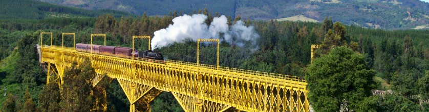
The Viaduct of Malleco is a railway bridge on the Malleco River designed and supervise by the Chilean engineer Victorino Aurelio Lastarria. It was constructed by Schneider et Cie. from Le Creusot, with parts manufactured in France. It was built between 1886 and 1889 and finished the same year with the Eiffel Tower in Paris. It was opened on October 26, 1890.
The Araucanía region is located between 37º 35′ and 39º 37’ latitude south and in it we find the Malleco Valley. Malleco means “water from clay” it comes from the native Mapudungun malle = clay and co = water, which is attributed to the colour of the river’s waters. The region is characterised by the continuity of the main relief units of the country which are the Andes to the east, the sunken basin at the centre, the Coastal Range and the coastal plains next to the Pacific Ocean to the west. This subregion comprises the counties of Angol, Collipulli, Ercilla, Los Sauces, Lumaco, Purén, Renaico, Traiguén and Victoria of the province of Malleco, which belongs to the ninth administrative region of the country. The area of Traiguén which includes the homonymous county limits to the north with the counties of Los Sauces and Ercilla; West with the county of Lumaco; South with the Galvarino and Perquenco counties (both of the province of Cautín) and East with the county of Victoria. Traiguén is located 65 kilometres to the South of the provincial capital, Angol, and 94 kilometres Northwest of Temuco, which is the capital of the IX region. The county of Traiguén has a area of 908.0 km2. It is the 7th province by size and the 4th in population: 20,622 inhabitants. The city of Traiguén is the capital of the homonymous county.
Denomination of Origin: Malleco
Region: Southern Region
Sub-Region: Malleco
Complementary Areas: Entre-Cordilleras, Andes
Soils
Here, the Andes are an active volcanic range with volcano peaks such as the Tolhuaca 2,780 metres high, Lonquimay 2,822 metres, Llaima 3,050 metres, the Villarrica 2,840. This activity has meant that large quantities of volcanic material have been deposited upon a granitic area and characterise the present soils of the area. During its formation, the Andes suffered the combined action of volcanic and glacial processes, which resulted in topography of soft slopes, U-shaped valleys with almost flat floors and precordilleran lacustrine basins. A chain of low hills, whose altitude varies between 600 and the 1,000 m.a.s.l, forms the pre-cordillera. Towards the South of the region we find precordilleran lakes such as Colico, Caburgua and Villarrica. In the sunken basin between the Andes and the Coastal Range the topography is characterised by a tectonic depression between the ranges, strongly undulated and interrupted by deep rivers. The altitude of the depression increases gradually, and reaches the 300 m.a.s.l. at Collipulli and Victoria. This large sunken area is also divided by basins which are separated by chains of hills which cross it in various directions. The valley is filled with materials of glacial, fluvial and volcanic origins that originated especially rich soils known as “trumao”. Another of the topographic features of this region is the presence of hills arising alone in the plains, isolated from chains or mountain ranges, such as the Pidenco and Pangal hills.
Climate
The climate of the region of the Araucanía where the Malleco Valley is located has transitional characteristics, as the temperate Mediterranean humid climate of the region of the Bio Bío is followed by a markedly rainy climate called temperate oceanic climate. This type of climate is found mainly in the Coastal Range and the Andean precordillera, and has more continental characteristics due to its relative distance from the sea. This causes a larger difference in temperatures with a daily minimum of 2°C and maximum of 23°C in the warmest months, rainfall varies between 1,500 and 2,500 mm; the dry season is one to two months’ long. To the north of the region the temperate warm climate characteristic of the Bío Bío region predominates, with less rainfall. The Nahuelbuta hills chain screens the influence of the ocean and captures the humid winds decreasing precipitation and increasing the dry periods. On the coast there is a type of climate known as western coast temperate oceanic, characterised by a high relative humidity and precipitation between 1,000 and 1,500 mm. The heights of the Coastal Range receive the largest rainfall. In the Andes the chill altitude climate predominates, characterised by the increase of precipitation to 3,000 mm a year and low temperature during the whole year. Above an altitude of 1,500 metres, precipitations are solid and temperatures below 0°C, the dry season lasts one to two months.
This region is characterised by the presence of the Imperial River to the north and the Toltén River to the South, defined as slow rivers regulated by precordilleran lakes. In the higher basin of the Imperial River the snowy summits of the volcanoes Tolhuaca 2,780 metres high and Llaima 3,124 metres high dominate the landscape. The river is formed near the city of Nueva Imperial by the joining of two rivers: the Cautín coming from the East and the Cholchón, which joins it from the north. The Toltén River is navigable by small vessels up to 30 kilometres inland. It has a mixed flow pattern, but the largest volumes occur in winter. The Toltén River is born at the western end of Lake Villarrica; it is 123 kilometres long and flows into the sea north of Punta Nilhue. Its main tributary is the Allipén, 108 kilometres long; its source is in the Andes, where it receives the waters of the Colico River, it has a mixed flow pattern but its largest volumes occur in winter. The Budi River flows to the sea between the Imperial and Toltén Rivers passing through a small homonymous lake. In the Andean zone of the Toltén River basin there are precordilleran lakes of glacial and volcanic origin. Their holding capacity regulates the flow of the rivers; these lakes are the Colico, the Villarrica fed by the waters coming down the Villarrica volcano, the Pucón River and Lake Caburgua.