Aconcagua Valley
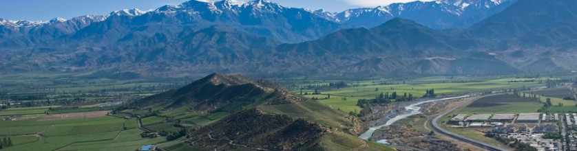
High above the valley, as a backdrop and rising to an altitude of 6.962 m above sea level, (22,838 ft), and by extension the highest point in both the Western Hemisphere and the Southern Hemisphere, looms the preposterously tall Mount Aconcagua, whose snowmelt provides during the summer months of unpolluted abundant irrigation for the valley’s bone-dry vineyards.
The Aconcagua region is a transition zone in the long territory of Chile. In it, we find the transversal valleys and homonymous rivers Petorca and La Ligua in the smaller northern area. The typical orographic units are a series of tectonic basins in the western foothills of the Andean range. Four relief units that determine soil types are distinguished in this region. To the East the Andes, a massive mountain range over 5,000 m.a.s.l., is the natural boundary of this region, among the highest summits, in addition to the Mount Aconcagua (which pick is located in the Argentinean territory), with 6.962 m above sea level, we find in the west side of the border the mountains of Los Leones 5,960 metres high; Tordillo with 4,670 metres and La Gloria’s 4,760 metres. There are also many mountain passes through the Andes. In the southern sector of the region the Andes range lies further east, thus allowing space for the basin of San Felipe de los Andes.
Denomination of Origin: Aconcagua
Region: Aconcagua
Sub-Region: Aconcagua
Complementary Area: Entre Cordilleras
Wineries in the Aconcagua Valley are:
Viña Almendral, www.vinaalmendral.cl
Arboleda Wines, www.arboledawines.com
Viña El Escorial, www.elescorial.cl
Viña Errázuriz, www.errazuriz.com
Fhaherty Wines, www.flahertywines.com
Viña Mendoza, http://www.vinodata.cl/winery/mendoza/
Viña Peumayen, www.peumayen.cl
Viña San Esteban, www.vse.cl
Viña Sánchez de Loria, www.sanchezdeloria.cl
Viña Seña, www.sena.cl
Viña von Siebenthal, www.vinavonsiebenthal.com
Viñedos Rosa Elvira, http://www.vinodata.cl/winery/vinedos-rosa-elvira/
Aconcagua Vintners Association, www.aconcagua.wine
Soils
Many rivers are born from the Andes mountain range; the most important is the Aconcagua River. Three large transversal valleys can be seen in the Valparaíso region, corresponding to the Petorca, La Ligua and Aconcagua rivers. The first two are located to the north of the region with sources in the Andes. The valleys are narrow with strongly inclined slopes and separated only by a transversal range of small hills: the rivers share an estuary on reaching the ocean, north of Punta La Ligua. The last valley to the south is that of the Aconcagua River. This river is joined by other affluents and forms a subsidence basin with many river terraces, resulting from the deposit of sedimentary rocks. Transversal ranges that issue from the western foothills of the Andes to join the Coastal Range frame these inland basins. An important range is that of Chacabuco in the South of the region, separating it from the Metropolitan region.
The Coastal Range determines the western geographic features of the Valparaíso administrative region, where the Aconcagua viticultural region is located. This relief system appears in the western sector of the Aconcagua valley with heights of around 2,000 metres such as: the Chache, El Roble and La Campana mountains, with altitudes of 2,333; 2,222 and 1,812 metres respectively. All are within a high and well-formed mountain range, some 35 to 40 kilometres distant from the Pacific Ocean coast. The contact of this mountain range with the inland sunken basin zone is through small basins framed by highlands. The main basins are La Ligua to the north of the El Melón mountain range, separated by this chain from the Catemu–Nogales basin. The Catemu–Nogales basin is limited to the South by the Aconcagua River and the La Calera hills. Seafront plains have soft and rolling hills framing tectonic basins and moulded valleys such as the Limache–Olmué basin to the Southwest of the La Campana Mountain, the Quilpué–Villa Alemana basin, to the west and the Curacaví and Casablanca basins further south. Because the Coastal Range is noticeably higher towards the South of the region, many small brooks are born there and flow to the sea; they are independent from the hydrographic system of the Andes. The Marga Marga, Casablanca, San Jerónimo, Puangue and Limache brooks originate from the range. The seafront plains are well developed in this region and have up to four levels at the foot of the Coastal Range, intermixing with river terraces in the valleys and estuaries. This unit is generally flat to slightly rolling and its maximum width is 20 to 30 kilometres inland, and its altitude up to 140 m.a.s.l. Dunes cover the lowest level, especially South of Quintero. To the north of this city and especially in the Horcones and Papudo coasts the plain ends as cliffs 20 to 100 metres high. Dune formations and beaches such as Algarrobo, El Quisco, El Tabo, Cartagena, San Antonio and Rocas de Santo Domingo alternate with coastal cliffs. The coast soils derive from marine terraces and their relief is flat to slightly steep, their colours are reddish-brown, and they are associated to other, less developed soils. On the western side of the Coastal Range, the soils evolved from granitic rocks and have high clay content in depth. There are alluvial soils in the inland valleys and also coarse-grained soils, which derived from vitreous volcanic materials typical of the central Andes.
Climate
From the climatic point of view, the Aconcagua Valley viticultural region has a temperate Mediterranean climate, with some variations. Towards the north of the Aconcagua River the climate is semiarid, while on the coast it is more humid, or Mediterranean seafront, and a highlands cold climate appears nearing the Andes. The Humboldt Current in the Pacific Ocean follows the Chilean coast from South to North and determines the climate of the region because it originates in Antarctic waters. The prevailing winds are of oceanic origin; they bring moisture and explain the constant presence of mists in the regional climate. The cold nature of the Humboldt Current determines the constant presence of a low temperature front next to the coast, and helps to lower continental temperatures. Four climate types are easily recognised in this region:
– A hot steppe climate is found north of the Aconcagua River, characterised by low atmospheric humidity, clear highly luminous skies, wide thermal fluctuations through the day and a mean annual temperatures of 15 °C. Rainfall is of 150 to 200 mm a year.
– A temperate Mediterranean-type seafront climate predominates in the entire coast of the region and its influence reaches inland through the valleys. Temperature variations are smaller due to the oceanic influence and are relatively stable during the year with a annual average of 14°C, the relative humidity reaches 75% and average rainfall is 450 mm.
– A warm temperate Mediterranean-type climate develops from the Aconcagua river Valley to the South; it is dryer and has a wider thermal range than that of the coast. The mean annual temperature is of 15,5 °C, and rainfall increases with altitude varying from about 250mm up to 300mm per year.
– A cold mountain climate in the Andes Mountain Range above 3,000 metres. Low temperatures and solid precipitation predominate, especially in winter time.
The Aconcagua region is considered as the northern limit of the mesomorphic zone, and its climate is regarded as temperate Mediterranean. Cloudiness is scarce and clear days vary between 240 and 300 days a year. Rainfall is concentrated in winter and followed by a period, which is drier than the rest of the year, from November to April. The region has many water-courses, due to its relief and rainfall. The main rivers are the Petorca, La Ligua and the Aconcagua River in the South of the region. The Petorca River flows near the northern boundary of the Valparaíso region with the Coquimbo region. The Petorca River is born of the confluence of the Pedernal and El Sobrante rivers in the precordilleran Chincolco sector and reaches the sea in the Bay of La Ligua; its waters irrigate the Petorca Valley. The La Ligua River is born from the union of the Alicahue River and the Cajón de los Ángeles brook. It is located south of the Petorca River, and its mouth is also in the La Ligua Bay. The La Ligua River is 162 kilometres long; it flows to the Southwest in its higher reaches and continues west in its middle and lower flow. The La Ligua River has a mixed flow pattern and is used to irrigate part of the La Ligua Valley. The Aconcagua River names the last transversal valley of the so named “Norte Chico” (Small North) and is located at the southern end of the region. The Aconcagua River is a result of the confluence of the Juncal and Blanco rivers in the Andes. The Putaendo River joins the Aconcagua River in the basin of San Felipe, and the Limache brook joins it before it reaches its mouth at Con Con. Its length, including the Juncal River, is of 177 km with a general direction from east to west. It has a mixed flow pattern: it is in spate in spring as a result of the thaw of the Andean snows and the rains explain its winter floods.